| U.S. Department
of Transportation
Federal Highway Administration Federal Transit Administration Bureau of Transportation Statistics |
|
||||||||||
|
|
|||||||||||
| Program
Description
Background |
|
|
|||||||||
CTPP 2000: In 1990, the CTPP data product was financed through a "pooled
fund" project administered through AASHTO for a "penny per person." We
hope that a similar funding mechanism will allow the development of both
statewide and urban elements for CTPP 2000. DOT is currently eliciting
input on standard tables and approaches to customize tabulations for CTPP
2000.
|
|
|
|
|
CB sends out TIGER/Line 1998® |
|
|
DOT sends out TAZ software |
|
|
MPOs and State DOTs submit TAZ boundaries to CB Regional Offices |
|
|
CB enters TAZs into TIGER ® |
|
|
CB returns TIGER/Line 1999® to MPOs and State DOTs for 1 month review |
The Census Bureau isn't planning to number the census blocks for Census 2000 until the Fall of 2000. So it is important for MPOs/DOTs to note that census blocks and other Census 2000 tabulation boundaries will not appear on the issued TAZ delineation maps discussed above. The 1990 boundaries may be included on these maps, if requested, as reference geographic boundaries.
Participants in the Census Bureau's Statistical Areas Program began receiving delineation maps and guidelines in early 1998. Census Bureau Regional Offices can provide the MPO/DOT with the name of their jurisdiction's contact. A list of Regional Offices is included in the June 1998 CTPP 2000 status report.
For the Census 2000 TAZ Update Program, MPOs and DOTs are being asked to define their TAZs prior to the census - enabling MPOs/ DOTs greater flexibility in defining their TAZs and an earlier release of the CTPP.
The Census Bureau will provide TAZ Delineation Maps and guidelines to MPOs/DOTs in early 1999. MPOs/DOTs will have the choice of receiving the delineation maps in digital format or as paper maps. Participants will have six months in which to delineate their TAZ boundaries and return the materials to the Census Bureau regional office. As the data are received, they will be added to the Census Bureau's geographic data base.
Beginning in early 2000, the Census Bureau will provide verification maps or digital files to each MPO/DOT for them to verify that their respective TAZs were inserted correctly before being used in Census 2000.
To be part of the TIGER file, each county can only have one definition of TAZs, so if an area falls within the planning boundaries of multiple MPOs, the MPOs must work together to define a single set of TAZs for TIGER.
Do I have to define Traffic Analysis Zones for the
CTPP?
No, you can get the Census Transportation Planning Package (CTPP) without
defining TAZs. You can use standard census geography, like census tracts
or block groups. You will need to make a decision by early 1999, when the
TAZ boundary definition for CTPP 2000 begins.
What are the advantages to defining TAZs?
TAZs are designed specifically for use with travel demand models. Therefore,
factors such as business concentrations and traffic flow are considered
in their design. Since census tracts and block groups are defined to count
residential population, they may not be the best geographic basis for transportation
analysis in commercial portions of a metropolitan area. For example tract
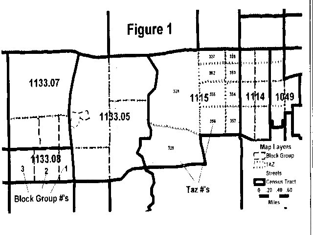
# 1115 in Figure 1 is a single block group but contains 10 TAZs. While
tract # 1113.08 is a single TAZ but is composed of 3 block groups.
How long (how many hours) will it take my MPO to enter the TAZ definitions
to give to the Census Bureau?
It depends on:
1. How many TAZs you have.
2. The type of process you choose, a paper map or
GIS software based process.
3. The present status of your TAZ boundary file.
Do you already have TAZs defined that you will want used in CTPP 2000,
or will you have to go through a review process to adjust TAZ boundaries
for CTPP 2000?